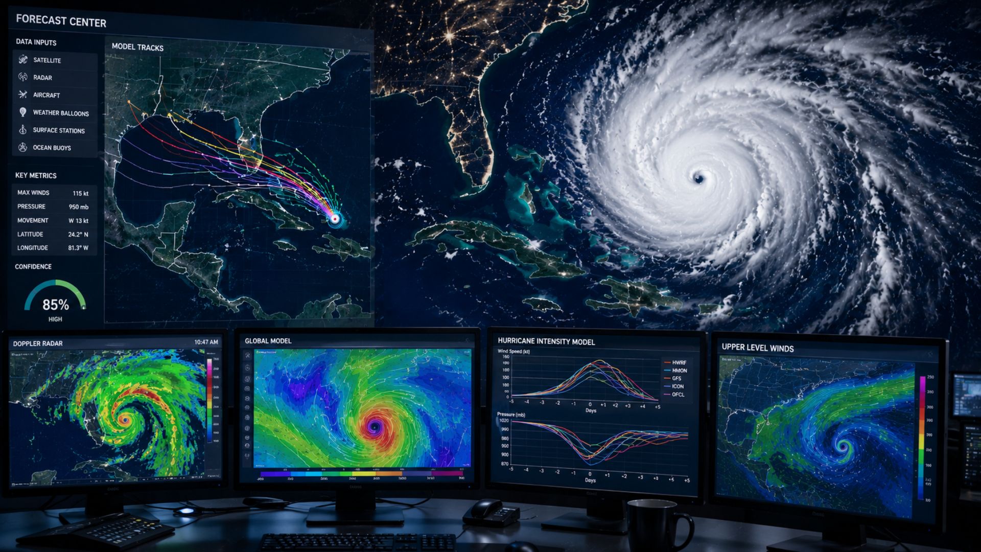

Meteorologists predict hurricanes by combining satellite observations, aircraft measurements, ocean and atmospheric data, radar, and computer weather models. This information helps forecasters determine where a hurricane may travel, how strong it could become, and what hazards it may bring to affected areas.
Hurricane forecasting involves two major questions: Where will the storm go, and how strong will it become?
Although these questions are closely related, they require meteorologists to analyze different parts of the atmosphere and ocean. A hurricane’s track is largely influenced by surrounding weather patterns, while changes in intensity depend on factors such as ocean temperatures, atmospheric moisture, wind shear, and the storm’s internal structure.
How Do Meteorologists Know a Hurricane Is Forming?
Before a hurricane exists, meteorologists monitor tropical regions for areas of disturbed weather that have the potential to organize into tropical cyclones.
Hurricanes require a specific combination of atmospheric and ocean conditions to develop.
Meteorologists look for factors such as:
- Warm ocean water
- Moist air
- Thunderstorm activity
- Low atmospheric pressure
- Relatively low vertical wind shear
- An organized area of rotation
Warm ocean water provides much of the energy that allows tropical cyclones to develop and strengthen.
As warm, moist air rises from near the ocean surface, atmospheric pressure near the surface can decrease. Additional air is drawn toward the lower-pressure area, where it can also become warm and moist.
If conditions remain favourable, thunderstorms can become increasingly organized around the developing circulation.
Not every tropical disturbance becomes a hurricane. Many systems encounter conditions that prevent them from organizing or strengthening.
What Tools Do Meteorologists Use to Predict Hurricanes?
Hurricane forecasting relies on a large observing network because these storms often develop and travel over oceans where traditional surface weather stations are limited.
Meteorologists combine observations from several sources to understand both the hurricane itself and the atmosphere surrounding it.
Weather Satellites
Satellites are among the most important tools for monitoring hurricanes.
Because tropical cyclones can spend much of their lifetime over the ocean, satellites provide meteorologists with a continuous view of areas that may otherwise have relatively few observations.
Satellite imagery allows forecasters to monitor:
- Cloud organization
- Thunderstorm development
- The location of the storm
- Movement
- The development of an eye
- Cloud-top temperatures
- Atmospheric moisture
- Changes in storm structure
Meteorologists can watch a tropical disturbance become increasingly organized and determine whether a defined circulation is developing.
Once a hurricane forms, satellites continue monitoring its structure and movement.
A well-organized hurricane may eventually develop a recognizable eye surrounded by intense thunderstorms known as the eyewall.
How Do Hurricane Hunter Aircraft Help Forecast Hurricanes?
One of the most interesting differences between hurricane forecasting and many other types of weather forecasting is the use of specialized aircraft.
When necessary, reconnaissance aircraft can fly into and around tropical cyclones to collect measurements that cannot be obtained as precisely from satellites alone.
Aircraft can measure conditions such as:
- Atmospheric pressure
- Wind speed
- Wind direction
- Temperature
- Humidity
- Storm structure
Aircraft can also release instruments called dropsondes.
A dropsonde falls through the storm and measures atmospheric conditions as it descends toward the ocean.
These observations provide meteorologists and computer models with detailed information about what is happening inside and around the hurricane.
This can help forecasters determine the storm’s current strength and improve their understanding of its structure.
How Do Computer Models Predict Hurricanes?
Computer weather models are essential for predicting where hurricanes will travel and how they may change.
Numerical weather prediction models use mathematical equations to simulate the atmosphere.
Meteorologists provide these models with enormous amounts of observational data from satellites, aircraft, weather balloons, ships, buoys, weather stations, and other observing systems.
The models then calculate how atmospheric conditions could evolve.
For hurricanes, models can provide guidance on:
- Storm track
- Forward speed
- Atmospheric pressure
- Wind patterns
- Storm intensity
- Rainfall
- Surrounding weather systems
- Potential land interaction
There are many different forecast models, and they do not always produce identical predictions.
Meteorologists therefore compare several models rather than simply choosing one.
Why Do Hurricane Forecast Models Show Different Tracks?
You may have seen hurricane graphics showing several possible tracks spreading outward from the storm.
Different models can predict different tracks because each model represents the atmosphere somewhat differently and small differences in initial conditions can grow over time.
For example, one model may predict that a high-pressure system will remain stronger for longer, steering the hurricane farther west.
Another may predict that the high weakens sooner, allowing the hurricane to turn north earlier.
Meteorologists compare these possibilities and examine which scenarios are best supported by observations.
They can also use ensemble forecasting, where a model is run many times with slightly different starting conditions.
If most ensemble members follow a similar path, confidence in the general forecast may increase.
If they spread across a large area, uncertainty is greater.
How Do Meteorologists Predict a Hurricane’s Path?
A hurricane does not decide its own direction.
Its movement is strongly influenced by large-scale winds and pressure systems in the surrounding atmosphere.
Meteorologists sometimes refer to these influences as steering currents.
High-pressure systems, low-pressure systems, troughs, ridges, and other atmospheric features can influence where a hurricane travels.
For example, a strong area of high pressure north of a hurricane may help steer it westward.
If a weakness develops in that high-pressure pattern, the hurricane may begin turning north.
Meteorologists therefore need to forecast not only the hurricane itself but also the atmosphere hundreds or even thousands of kilometres around it.
This is one reason satellite observations and global weather models are so important for hurricane forecasting.
What Is the Hurricane Forecast Cone?
Hurricane forecasts are commonly displayed using a forecast cone, sometimes called the cone of uncertainty.
The cone represents the probable region in which the centre of the tropical cyclone could travel based on historical forecast errors.
It is important to understand what the cone does not mean.
The cone does not show the size of the hurricane, and it does not indicate that hazards will occur only inside it.
A large hurricane can produce dangerous winds, heavy rainfall, waves, and storm surge well outside the forecast cone.
The centre of the storm can also ultimately travel anywhere within the forecast area.
People should therefore pay attention to the complete forecast and official warnings rather than focusing only on the centre line of a hurricane track.
How Do Meteorologists Predict Hurricane Strength?
Predicting hurricane intensity can be particularly challenging.
Meteorologists examine both the environment surrounding the hurricane and changes occurring within the storm itself.
Several factors can influence whether a hurricane strengthens or weakens.
Ocean Temperature
Warm ocean water provides energy to tropical cyclones.
A hurricane travelling over sufficiently warm water can have access to the heat and moisture necessary to maintain or increase its strength.
However, the temperature at the immediate ocean surface is not the only consideration.
Meteorologists can also examine how deeply warm water extends beneath the surface.
A deep layer of warm ocean water can provide a hurricane with a larger reservoir of energy.
Wind Shear
Vertical wind shear describes changes in wind speed or direction with height.
Strong wind shear can disrupt the organization of a tropical cyclone by pushing thunderstorms away from its centre.
Lower wind shear generally provides a more favourable environment for a hurricane to remain vertically organized.
Meteorologists therefore closely monitor predicted wind shear around a storm.
Atmospheric Moisture
Hurricanes depend on warm, moist air.
Dry air entering the storm’s circulation can interfere with thunderstorm development and potentially limit strengthening.
Meteorologists use satellite observations and weather models to identify areas of dry and moist air surrounding tropical systems.
Internal Storm Structure
Changes within the hurricane itself can also affect its intensity.
Meteorologists monitor the eye, eyewall, rainbands, and distribution of thunderstorms around the centre.
A hurricane’s internal structure can change considerably, sometimes resulting in periods of rapid strengthening or temporary weakening.
What Is Rapid Intensification?
One of the most challenging aspects of hurricane forecasting is predicting rapid intensification.
Rapid intensification occurs when a tropical cyclone’s maximum sustained winds increase substantially over a relatively short period.
A hurricane moving through very warm water, abundant atmospheric moisture, and low wind shear may encounter an environment favourable for rapid strengthening.
However, having favourable conditions does not guarantee rapid intensification.
The internal structure of the hurricane also matters.
Meteorologists use satellite observations, aircraft measurements, ocean data, and increasingly sophisticated forecast models to assess the possibility of rapid strengthening.
Predicting exactly when rapid intensification will begin and how strong a hurricane will ultimately become remains a difficult forecasting problem.
How Does Weather Radar Help Predict Hurricanes?
Weather radar becomes especially useful as a hurricane approaches land.
Radar can provide detailed information about precipitation and movement within the storm.
Meteorologists can use radar to observe:
- The eye and eyewall
- Rainbands
- Areas of intense rainfall
- Storm movement
- Wind patterns
- Changes in storm structure
Doppler radar can also detect movement within precipitation, helping meteorologists analyze winds and areas of rotation.
However, radar has a limited geographic range.
Satellites and aircraft observations are therefore generally much more important while hurricanes remain far from land.
How Do Ocean Buoys Help Forecast Hurricanes?
Ocean observations provide valuable information about conditions underneath and around tropical cyclones.
Buoys can measure variables such as:
- Ocean temperature
- Air temperature
- Atmospheric pressure
- Wind
- Waves
Ships and other ocean observing systems can provide additional measurements.
These observations help meteorologists determine whether actual conditions match what satellites and computer models are showing.
They can also provide direct measurements as a tropical cyclone passes nearby.
How Do Meteorologists Predict Hurricane Rainfall?
Wind is only one hazard associated with hurricanes.
Tropical cyclones can transport enormous amounts of moisture and produce extremely heavy rainfall, sometimes far from the storm’s centre.
Meteorologists use weather models to predict how moisture will move around the hurricane and where the heaviest precipitation could occur.
Rainfall totals can depend on several factors, including:
- Storm speed
- Storm track
- Atmospheric moisture
- Terrain
- Interaction with weather fronts
- Duration of rainfall
A slower-moving tropical cyclone can produce particularly serious rainfall totals because heavy rain may continue over the same area for an extended period.
A hurricane does not need to make a direct landfall over a location to produce dangerous flooding there.
How Do Meteorologists Predict Storm Surge?
Storm surge is another major hurricane hazard.
Strong winds can push ocean water toward the coastline, causing water levels to rise above normally expected levels.
The severity of storm surge depends on more than hurricane category.
Meteorologists and ocean forecasters consider factors such as:
- Wind speed
- Wind direction
- Storm size
- Storm track
- Forward speed
- Coastal shape
- Ocean depth near the coastline
- Tides
A large hurricane can push water across a broad section of coastline.
Local geography can make certain areas particularly vulnerable as water is funnelled into bays, harbours, or other coastal features.
For this reason, forecasts focus on individual hazards rather than assuming a hurricane’s category alone describes how dangerous it will be.
Why Can Hurricane Forecasts Change?
Hurricane forecasts change because both the storm and its surrounding atmosphere are constantly evolving.
A relatively small change in a high-pressure system hundreds of kilometres away could eventually influence the hurricane’s track.
Changes in wind shear, atmospheric moisture, or ocean conditions can affect intensity.
Meteorologists continually receive new information from satellites, aircraft, weather models, ocean observations, and other instruments.
As these observations are incorporated into newer forecasts, the predicted track or intensity may shift.
A changing hurricane forecast therefore does not necessarily mean something went wrong with the previous forecast. It often reflects new information about an evolving atmosphere.
Is It Easier to Predict a Hurricane’s Track or Strength?
In general, predicting the track of a hurricane has historically improved considerably, while predicting exactly how its intensity will change remains especially challenging.
A hurricane’s path is strongly influenced by large-scale atmospheric patterns that modern global weather models can simulate.
Intensity depends on a complicated interaction between the ocean, surrounding atmosphere, and processes occurring inside the hurricane itself.
Small-scale changes near the eye and eyewall can have major effects on wind speed.
This is why a forecast can have relatively high confidence in the general path of a hurricane while still having considerable uncertainty about how strong the storm will be when it reaches a particular location.
How Far in Advance Can Meteorologists Predict Hurricanes?
Meteorologists can monitor the potential for tropical cyclone development before a hurricane actually forms.
Once a tropical cyclone develops, forecast centres produce track and intensity predictions extending several days into the future.
Uncertainty generally increases farther into the forecast period.
The expected track several days away can shift as atmospheric conditions evolve and new observations become available.
The same applies to intensity.
Meteorologists may know that conditions are favourable for strengthening without being able to determine exactly how powerful the hurricane will become several days later.
This is why people in potentially affected regions should continue monitoring updated forecasts rather than relying on a hurricane track viewed several days earlier.
How Are Hurricanes Forecast in Canada?
Environment and Climate Change Canada’s Canadian Hurricane Centre (CHC) is responsible for providing specialized information about tropical cyclones that could affect Canada or Canadian waters.
The Canadian Hurricane Centre monitors large-scale weather patterns and global hurricane models throughout the Atlantic hurricane season. When a tropical cyclone could threaten Canadian waters, forecasters analyze its expected track, intensity, winds, rainfall, waves, and other potential hazards.
The CHC also works closely with the United States National Hurricane Center and adds detailed Canadian forecasts and warnings when storms threaten Canada.
When a tropical cyclone is expected to reach Canadian waters within approximately 72 hours, the Canadian Hurricane Centre can begin dedicated around-the-clock forecast operations and issue regular updates as the storm approaches.
What Is the Difference Between a Hurricane Watch and Warning in Canada?
A Hurricane Watch means hurricane conditions are possible in a specified area, generally within 36 hours.
A Hurricane Warning indicates hurricane conditions are expected, generally within 24 hours.
Canadian hurricane alerts consider more than wind alone. Tropical cyclones can also produce dangerous coastal water levels, waves, rainfall, and flooding.
This is another reason people should not judge the potential impact of a hurricane solely by its category.
How Accurate Are Hurricane Forecasts?
Hurricane forecasting has improved considerably, but no forecast can predict the exact future location and strength of a storm with complete certainty.
The Canadian Hurricane Centre notes that uncertainty increases with forecast time. Its published average position errors are approximately 70 kilometres at 12 hours, 100 kilometres at 24 hours, 150 kilometres at 36 hours, and around 200 kilometres at 48 hours.
Forecast centres therefore rely on multiple computer models, including dynamical, statistical, statistical-dynamical, ensemble, consensus, and increasingly AI-based forecasting systems. Human forecasters interpret this guidance alongside observations rather than relying on a single model.
The Bottom Line
Meteorologists predict hurricanes by combining observations from satellites, hurricane reconnaissance aircraft, radar, ocean instruments, surface observations, and other sources with sophisticated computer weather models.
Forecasting involves determining both where the hurricane will go and how its strength may change.
Large-scale atmospheric patterns help meteorologists predict the storm’s track, while ocean temperatures, atmospheric moisture, wind shear, and the hurricane’s internal structure provide clues about its future intensity.