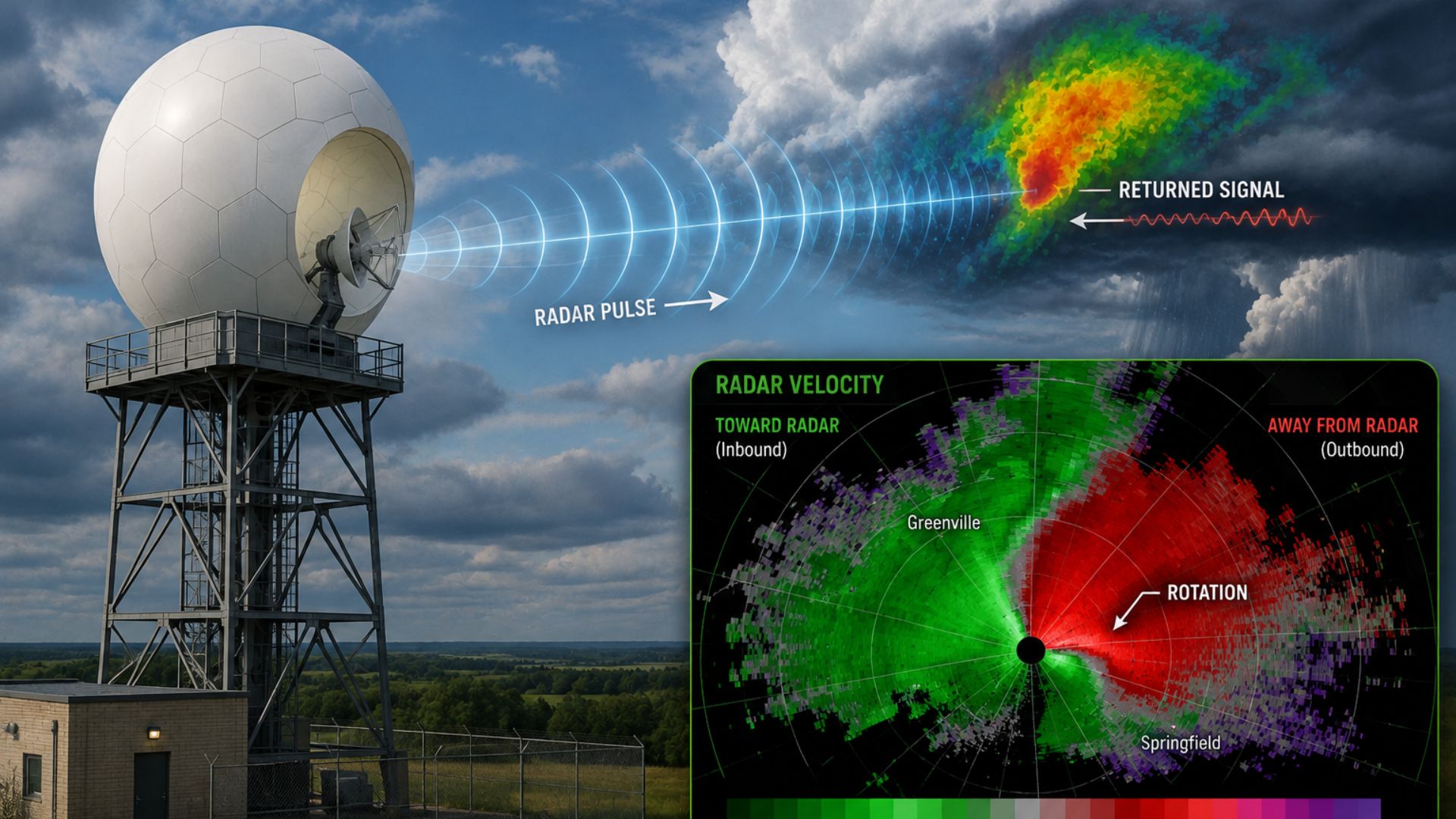

Doppler radar works by sending pulses of radio waves into the atmosphere and measuring the signals that return after striking rain, snow, hail, or other particles. In addition to showing where precipitation is occurring, Doppler radar can detect whether those particles are moving toward or away from the radar, giving meteorologists valuable information about wind and movement inside storms.
This ability to measure motion is what makes Doppler radar particularly useful for tracking thunderstorms, identifying areas of strong wind, and detecting rotation that could indicate the potential for a tornado.
What Is Doppler Radar?
Doppler radar is a type of weather radar that uses the Doppler effect to measure the movement of precipitation and other particles in the atmosphere.
Traditional weather radar can determine where precipitation is located and provide information about its intensity. Doppler radar adds another important measurement: velocity.
By measuring whether particles are moving toward or away from the radar, meteorologists can examine how winds are behaving inside a storm.
This provides two of the most important types of radar information:
- Reflectivity — where precipitation is located and how strongly energy is being reflected back to the radar.
- Velocity — how quickly particles are moving toward or away from the radar.
Together, these measurements give meteorologists a much better understanding of what is happening inside a weather system.
How Does Doppler Radar Work?
The Doppler radar process can be broken down into a few basic steps.
1. The Radar Sends Out Radio Waves
A radar antenna sends short pulses of radio-wave energy into the atmosphere.
These pulses travel outward from the radar until they encounter objects such as raindrops, snowflakes, hailstones, or other particles.
2. Precipitation Reflects Some Energy Back
When the radio waves encounter precipitation, some of their energy is scattered in different directions.
A small portion returns toward the radar antenna.
The radar measures this returning signal, often called an echo, to determine where precipitation is located and how strong the return is.
3. The Radar Determines Distance
Radar can determine how far away precipitation is by measuring how long it takes for a pulse to travel outward and return.
Because radio waves travel at approximately the speed of light, the time between transmission and reception can be used to calculate the distance to the target.
This allows the radar to map precipitation over a large surrounding area.
4. The Doppler Effect Measures Motion
Doppler radar also examines changes in the frequency or phase of the returned signal caused by moving particles.
If precipitation is moving toward the radar, the returned signal changes differently than it does when precipitation is moving away from the radar.
Meteorologists use these differences to calculate radial velocity—the component of motion directly toward or away from the radar.
5. The Data Becomes a Radar Image
The radar repeatedly scans the atmosphere from different directions and elevations.
Computers process the measurements and convert them into radar products that meteorologists can analyze.
These maps can show precipitation location, intensity, movement, storm structure, wind patterns, and other information.
What Is the Doppler Effect?
The Doppler effect is the change in the observed frequency of a wave when there is motion between the source and the observer.
A familiar example is the sound of an emergency vehicle siren. The pitch sounds higher as the vehicle approaches and lower after it passes and begins moving away.
Doppler weather radar applies the same basic principle to electromagnetic waves rather than sound waves.
When precipitation particles move toward or away from the radar, they cause a measurable change in the returned radar signal. That change allows the radar to estimate their motion relative to the radar.
What Does Doppler Radar Detect?
Doppler radar can provide information about several important aspects of the weather.
Rain
Radar is commonly used to locate areas of rain and monitor how they move.
Stronger radar returns can indicate areas containing more or larger precipitation particles, helping meteorologists identify heavier areas of rainfall.
Radar is especially useful for monitoring showers and thunderstorms because precipitation can vary considerably over short distances.
Read More: How Do Meteorologists Predict Rain?
Snow
Doppler radar can also detect snow, although snow can produce different radar returns than rain because snowflakes have different shapes, densities, and water content.
Radar helps meteorologists determine where snow is falling, how snow bands are moving, and where heavier precipitation may be developing.
This can be particularly useful during lake-effect snow and snow squalls, where narrow bands can produce dramatically different conditions over relatively short distances.
Read More: How Do Meteorologists Predict Snow?
Hail
Strong thunderstorms can contain hail, which can produce strong radar returns.
Modern weather radar provides several measurements that meteorologists can use together to assess whether hail is likely within a storm and potentially estimate where larger hail may be occurring.
Thunderstorms
Doppler radar is one of the most important tools for monitoring thunderstorms after they develop.
Meteorologists can track a storm’s location, movement, precipitation intensity, internal wind patterns, and structural changes.
Radar can also help determine whether a thunderstorm is strengthening, weakening, or developing characteristics associated with severe weather.
Read More: How Do Meteorologists Predict Thunderstorms?
How Does Doppler Radar Measure Wind?
Doppler radar does not measure every aspect of the wind directly.
Instead, it measures the movement of precipitation and other particles toward or away from the radar. Meteorologists generally assume these particles are moving with the surrounding air closely enough to provide useful information about the wind.
This measurement is known as radial velocity.
A radar can determine that particles are moving rapidly toward it or rapidly away from it, but it cannot directly measure the portion of the wind moving perfectly perpendicular to the radar beam.
Meteorologists therefore interpret velocity patterns across a storm rather than treating each radar measurement as a complete measurement of the wind.
Read More: How Do Meteorologists Predict Wind?
What Do the Colours on Doppler Radar Mean?
The meaning of radar colours depends on which radar product you are viewing.
This is an important distinction because reflectivity and velocity maps use colour for different purposes.
Reflectivity Radar
On a typical reflectivity map, colours represent the strength of the returned radar signal.
Lower-intensity precipitation is commonly represented by cooler colours such as blue or green, while stronger returns may progress through yellow, orange, red, and sometimes other colours.
A stronger return does not automatically mean severe weather. It indicates that more energy is being reflected back to the radar, which can be influenced by the amount, size, type, and concentration of particles.
Velocity Radar
Velocity maps show motion relative to the radar.
A commonly used colour scheme displays one set of colours for particles moving toward the radar and another for particles moving away from the radar.
The important information is not simply the colour itself but the pattern those velocities create.
Meteorologists can use these patterns to identify strong winds and areas where winds may be changing direction over a relatively short distance.
How Does Doppler Radar Detect Rotation?
One of Doppler radar’s most important severe-weather applications is detecting rotation within thunderstorms.
Meteorologists examine velocity data for areas where winds moving toward the radar appear very close to winds moving away from the radar.
This tightly packed change in velocity can indicate that air within the storm is rotating.
In a rotating severe thunderstorm, radar may detect a broader rotating updraft known as a mesocyclone. Strong or tightening rotation can increase concern that a storm may be capable of producing a tornado.
However, radar-detected rotation does not automatically mean a tornado is occurring.
Meteorologists must consider the strength, depth, persistence, and location of the rotation along with other radar products, storm structure, environmental conditions, and reports from the ground.
Can Doppler Radar See Tornadoes?
Doppler radar does not normally show a tornado as a clearly visible funnel on a radar map.
Instead, it can detect signatures associated with tornado development or an ongoing tornado.
Velocity data may reveal strong rotation inside a thunderstorm. Modern radar can also provide information about the shapes and types of objects producing radar returns.
In some tornadoes, radar may detect debris that has been lifted into the air. When debris-related information appears in the same location as strong rotation, it can provide strong evidence that a tornado is occurring.
Radar is therefore an extremely important tornado-detection tool, but meteorologists also rely on storm spotters, observations, environmental data, and other information.
Read More: How Do Meteorologists Predict Tornadoes?
What Is Dual-Polarization Radar?
Modern Doppler weather radars may use dual-polarization technology.
Instead of transmitting and receiving radio-wave energy in only one orientation, dual-polarization radar uses both horizontal and vertical orientations.
This gives meteorologists additional information about the size, shape, orientation, and type of particles being detected.
Dual-polarization data can help distinguish between different targets, including:
- Rain
- Snow
- Hail
- Ice particles
- Non-weather targets
- Tornado debris in certain situations
This additional information can improve precipitation analysis and severe-weather detection.
Can Doppler Radar Predict the Weather?
Doppler radar is primarily an observation and monitoring tool, not a long-range weather prediction model.
It shows meteorologists what is happening in the atmosphere now and how precipitation and storms are moving.
That information can still be extremely useful for short-term forecasting.
For example, if radar shows a line of thunderstorms moving toward a city, meteorologists can estimate when the storms may arrive and monitor whether they are strengthening or weakening.
For forecasts several days into the future, meteorologists rely much more heavily on observations, weather models, ensembles, satellite information, and other forecasting tools.
Read More: How Do Weather Models Work?
How Far Can Doppler Radar See?
Weather radar can detect precipitation hundreds of kilometres away under some circumstances, but its usefulness changes with distance.
Radar beams do not travel flat along the Earth’s surface. Because of the curvature of the Earth and the way the beam travels through the atmosphere, the beam becomes increasingly high above the surface as distance from the radar increases.
This means a radar may detect the upper portions of a distant storm while missing precipitation or wind occurring much closer to the ground.
The radar beam also spreads as it travels, reducing the amount of detail available at greater distances.
For this reason, a network of radar sites provides better coverage than relying on a single radar.
Why Does Radar Sometimes Show Rain When It Isn’t Raining?
Not everything detected by weather radar is precipitation reaching the ground.
Radar can sometimes detect:
- Precipitation evaporating before reaching the surface
- Birds
- Insects
- Smoke or other airborne particles
- Ground objects
- Atmospheric boundaries
- Other non-weather targets
Precipitation can also be detected high above the surface but evaporate while falling through a layer of dry air. This is known as virga.
Meteorologists use multiple radar products and other observations to determine whether a radar return represents actual precipitation at the surface.
What Are the Limitations of Doppler Radar?
Doppler radar is extremely useful, but it does not provide a perfect view of the atmosphere.
Its limitations include distance from the radar, terrain blocking the beam, the increasing height of the beam with distance, non-weather targets, and difficulty observing winds that are moving perpendicular to the radar beam.
Radar also cannot tell meteorologists everything about what will happen next.
It is most valuable when combined with other observing and forecasting systems.
How Do Meteorologists Use Doppler Radar?
Meteorologists use Doppler radar alongside weather satellites, weather balloons, surface weather stations, lightning data, weather models, and direct observations.
Each tool provides a different view of the atmosphere.
Weather models help predict how conditions may develop hours or days into the future. Satellites provide a broad view of clouds and weather systems. Weather balloons measure conditions at different heights in the atmosphere.
Doppler radar provides detailed, frequently updated information about precipitation and movement within storms.
Together, these tools allow meteorologists to understand both what the atmosphere is doing now and what it may do next.
The Bottom Line
Doppler radar works by sending radio waves into the atmosphere and analyzing the energy that returns after interacting with precipitation and other particles. The strength of the returned signal helps meteorologists locate and assess precipitation, while the Doppler effect reveals whether particles are moving toward or away from the radar.