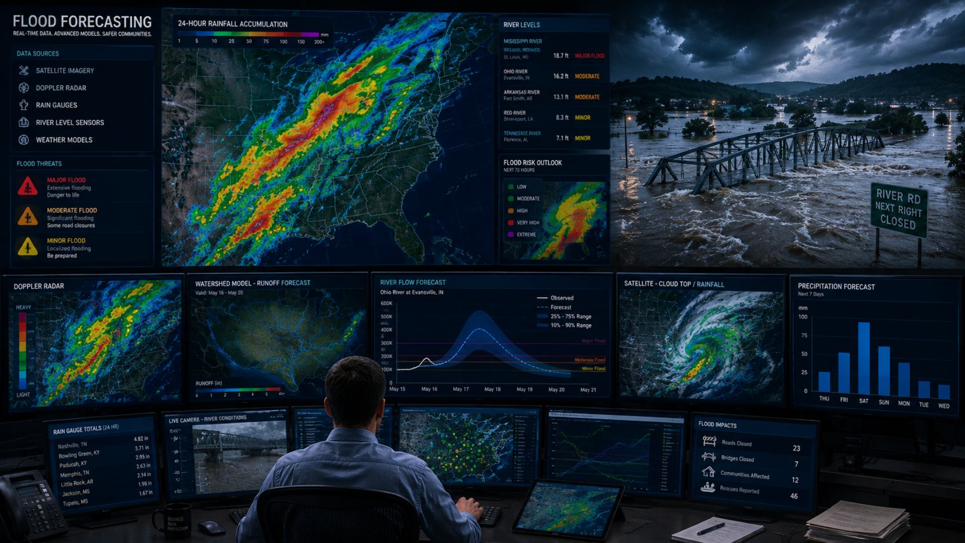

Meteorologists predict floods by forecasting how much rain or snowmelt an area may receive and combining that information with river levels, soil moisture, terrain, drainage conditions, and hydrologic models. They use weather radar, satellites, rain gauges, river gauges, weather stations, and computer models to determine where water could accumulate and whether rivers, streams, or other waterways may rise to dangerous levels.
Flood forecasting is different from simply predicting heavy rain. The same amount of rainfall can produce very different results depending on where it falls and what conditions existed beforehand.
If the ground is already saturated or rivers are running high, additional rain can quickly increase the risk of flooding. If the soil is relatively dry and rivers are low, the same rainfall may have a much smaller impact.
How Do Meteorologists Know When Flooding Could Happen?
Meteorologists first need to determine how much water may enter an area.
Rainfall is one of the most common causes, but flooding can also result from melting snow, ice jams, storm surge, thunderstorms, or combinations of several factors.
Forecasters examine several conditions, including:
- Expected rainfall
- Rainfall intensity
- Duration of rainfall
- Previous rainfall
- Snowpack and snowmelt
- Soil moisture
- River and stream levels
- Terrain
- Drainage
- Frozen ground
- Ice conditions
These factors help determine what will happen to water after it reaches the ground.
Meteorologists and hydrologists then use computer models to estimate how quickly that water could enter streams and rivers and how high water levels may rise.
What Tools Are Used to Predict Floods?
Flood forecasting requires information about both the atmosphere and the ground.
Meteorologists need to predict how much precipitation will fall, while hydrologic observations and models help determine where that water will go.
Weather Radar
Weather radar is one of the most important tools for monitoring rainfall.
Radar sends pulses of energy into the atmosphere and measures signals reflected by precipitation.
Meteorologists can use radar to identify:
- Where rain is falling
- Rainfall intensity
- Movement of precipitation
- Areas of heavy rain
- Thunderstorms
- Repeated rainfall over the same location
Radar becomes particularly valuable during rapidly developing flood situations.
If thunderstorms repeatedly move across the same watershed, radar can show meteorologists that large amounts of rain may be accumulating over a relatively small area.
This can provide an early indication that flooding may become possible.
How Do Satellites Help Predict Floods?
Weather satellites allow meteorologists to monitor large storm systems and atmospheric moisture.
Satellite imagery can show cloud development, moisture patterns, storm movement, and large areas of precipitation.
This becomes particularly important before heavy rain reaches an area.
Meteorologists may be able to monitor a large weather system approaching Canada several days before it arrives and use satellite observations to determine whether it is developing as expected.
Satellites can also provide information about conditions on the Earth’s surface.
Depending on the instrument, satellite observations may help monitor snow cover, vegetation, soil moisture, and areas affected by flooding.
This gives forecasters another source of information when evaluating flood risk across large regions.
How Do Rain Gauges Help Predict Floods?
Rain gauges provide direct measurements of how much precipitation has actually reached the ground.
This information is important because radar estimates rainfall remotely.
Meteorologists can compare radar estimates with measurements from rain gauges to better understand how much rain has fallen.
A network of rain gauges can reveal where the heaviest precipitation has occurred and whether rainfall totals are approaching dangerous levels.
During a major rainfall event, forecasters continually compare predicted rainfall with observed rainfall.
If significantly more rain falls than expected, the flood risk can increase.
How Are River Levels Monitored?
River and stream gauges are another critical part of flood monitoring.
These instruments measure water levels at specific locations along waterways.
Some monitoring stations can also provide information about streamflow, which describes the volume of water moving through a river or stream over time.
Forecasters can compare current river levels with:
- Normal conditions
- Previous flood levels
- Flood thresholds
- Predicted river levels
- Historical observations
A river that is already unusually high before heavy rain arrives may require considerably less additional water to flood surrounding areas.
Real-time river observations therefore provide essential information about how vulnerable a watershed is before and during a storm.
What Are Hydrologic Models?
Weather models predict what will happen in the atmosphere.
Hydrologic models help predict what will happen to water after it reaches the ground.
These models simulate how rainfall and melting snow move through a watershed.
They can account for factors such as:
- Rainfall
- Snowmelt
- Soil moisture
- Infiltration
- Runoff
- River flow
- Terrain
- Watershed characteristics
Meteorologists and hydrologists can input forecast precipitation into these models to estimate how rivers and streams may respond.
For example, a weather model might predict 70 millimetres of rain over a watershed.
A hydrologic model can then help estimate how much of that water could become runoff, when it may reach a river, and how high the river could rise.
What Is a Watershed?
A watershed is an area of land where water drains toward a common river, lake, stream, or other body of water.
Watersheds are extremely important in flood forecasting.
Rain does not need to fall directly beside a river to cause that river to rise.
Water falling kilometres away can flow downhill through smaller streams and tributaries before eventually entering a larger river.
Meteorologists therefore need to know not only how much rain will fall but where it will fall within the watershed.
Heavy rain concentrated in an important part of a watershed can sometimes create a much greater flood response than the same amount of rain spread across a different area.
Why Does Soil Moisture Matter?
The amount of water already stored in the ground can dramatically affect flood risk.
Dry soil can absorb some rainfall through a process called infiltration.
As the soil becomes wetter, its ability to absorb additional water can decrease.
Eventually, the ground may become saturated.
When saturated soil cannot absorb much additional rainfall, more water remains at the surface and becomes runoff.
This water can flow into:
- Ditches
- Storm drains
- Streams
- Creeks
- Rivers
- Low-lying areas
Meteorologists and hydrologists therefore consider rainfall from previous days or weeks when evaluating an approaching storm.
A moderate rainfall event following weeks of wet weather could potentially create a greater flood risk than a heavier storm following a prolonged dry period.
How Does Frozen Ground Affect Flooding?
Frozen ground can create additional flood concerns during winter and early spring.
Water may have difficulty soaking into deeply frozen soil.
If rain falls onto frozen or partially frozen ground, a greater proportion can potentially become surface runoff.
The situation can become more serious when rain combines with melting snow.
Meteorologists forecasting spring flooding therefore need to consider several factors simultaneously, including:
- Snow depth
- Water contained within the snowpack
- Temperature
- Rainfall
- Rate of snowmelt
- Soil conditions
- River levels
- Ice conditions
These factors are particularly important across parts of Canada where large snowpacks can accumulate during winter.
How Do Meteorologists Predict Flooding From Snowmelt?
Snow acts as a temporary reservoir of water.
When temperatures rise, that stored water begins entering the environment.
Meteorologists monitor how much water is contained in the snowpack and how quickly temperatures are expected to rise.
A gradual melt may allow water to enter rivers over a longer period.
A sudden warm spell can release water much more quickly.
Rain can accelerate the process.
When substantial rainfall occurs while snow is melting, water from both sources can enter rivers and streams simultaneously.
Meteorologists therefore use temperature forecasts, rainfall forecasts, snow observations, and hydrologic models to estimate how quickly runoff could increase.
What Is Snow Water Equivalent?
Snow depth alone does not tell meteorologists how much water is stored in a snowpack.
Ten centimetres of light, fluffy snow contains much less water than ten centimetres of dense, wet snow.
Forecasters therefore use a measurement called snow water equivalent, or SWE.
Snow water equivalent represents the depth of liquid water that would remain if the snowpack completely melted.
This measurement is especially useful when forecasting spring floods.
A deep snowpack containing a large amount of water can create a significant runoff threat if temperatures rise quickly or heavy rain occurs during the melt.
How Do Ice Jams Cause Flooding?
Flooding can sometimes occur even without extreme rainfall.
During winter and spring, river ice can break apart and begin moving downstream.
Pieces of ice can accumulate at narrow sections, bends, bridges, islands, or other obstructions.
This creates an ice jam.
The jam can restrict the normal movement of water and cause river levels to rise rapidly upstream.
Ice-jam flooding can be particularly difficult to predict because the exact location and timing of a jam may depend on local river conditions.
Meteorologists and hydrologists monitor temperatures, river levels, ice conditions, and expected snowmelt when assessing this risk.
How Do Meteorologists Predict Flash Floods?
Flash floods are especially dangerous because they can develop very quickly.
They are often associated with intense rainfall over a short period.
Meteorologists forecasting flash flooding pay close attention to rainfall rates.
A location receiving 50 millimetres of rain over several days may respond very differently from a location receiving the same amount in one hour.
Intense rainfall can overwhelm the ground’s ability to absorb water and exceed the capacity of drainage systems.
Radar becomes especially valuable during these events because meteorologists can monitor heavy rainfall almost continuously.
Forecasters also examine whether thunderstorms are repeatedly moving over the same locations.
What Is Thunderstorm Training?
Sometimes thunderstorms repeatedly move across the same area.
This is commonly called training because the storms can resemble train cars following the same track.
Training thunderstorms can produce extremely high rainfall totals over relatively small areas.
One storm may move away only for another to develop or arrive behind it.
Meteorologists monitor radar closely to determine whether this pattern is occurring.
If the storms continue moving across the same watershed or urban area, the risk of flash flooding can increase rapidly.
How Do Meteorologists Predict River Flooding?
River flooding often develops more slowly than flash flooding.
Meteorologists first forecast how much precipitation will fall across the river’s watershed.
Hydrologic models can then estimate how that precipitation will move through streams and tributaries into the main river.
Forecasters can produce a river level forecast, sometimes called a river stage forecast.
This estimates how high the river may rise and when it could reach its peak.
The timing can vary substantially depending on the size of the watershed.
Small rivers may respond relatively quickly to heavy rainfall, while major river systems can take considerably longer.
This can allow river flooding to continue or even worsen after the rain has stopped.
How Do Meteorologists Predict Urban Flooding?
Cities respond to heavy rainfall differently than many rural areas.
Urban environments contain large areas of:
- Roads
- Parking lots
- Sidewalks
- Buildings
- Other impermeable surfaces
Water cannot easily soak through these surfaces.
Instead, it runs toward storm drains, sewers, streams, and low-lying areas.
When rainfall becomes more intense than the drainage system can handle, water can accumulate quickly.
Meteorologists forecasting urban flood potential therefore pay close attention to rainfall intensity and duration.
Local infrastructure and drainage authorities may then use those forecasts to assess which areas could be vulnerable.
How Does Terrain Affect Flood Risk?
Water naturally flows downhill, making terrain an important part of flood forecasting.
Low-lying areas, valleys, and locations beside rivers can be particularly vulnerable.
Steep terrain can create a different problem.
Heavy rain falling on hills or mountains can flow downhill rapidly instead of remaining where it fell.
This can cause streams to rise quickly farther downstream.
Hydrologic models use elevation and watershed information to estimate how water will move across the landscape.
Local geography can therefore cause two communities receiving similar rainfall totals to experience very different impacts.
Why Can Flooding Happen After the Rain Stops?
The end of the rain does not necessarily mean the flood threat has ended.
Water takes time to move through a watershed.
Rain that falls upstream can continue travelling through tributaries toward larger rivers for hours or even days.
As a result, some rivers may continue rising after skies have cleared.
Large river systems can respond especially slowly.
This is why flood forecasts often include the expected time of the river’s peak rather than simply the time when rainfall ends.
How Do Meteorologists Predict Coastal Flooding?
Coastal flooding is different from flooding caused primarily by rainfall.
Strong winds associated with powerful storms can push ocean water toward the coast.
Low atmospheric pressure can also contribute to elevated water levels.
Meteorologists and ocean forecasters consider:
- Storm track
- Wind speed
- Wind direction
- Atmospheric pressure
- Waves
- Tides
- Coastal geography
During tropical cyclones, this abnormal rise in ocean water can become a dangerous storm surge.
Coastal flooding can also occur during powerful non-tropical storms, particularly when strong onshore winds coincide with high tides and large waves.
Why Are Floods Difficult to Predict?
Flood forecasting requires meteorologists to predict both the weather and how the landscape will respond to it.
Uncertainty in the rainfall forecast can therefore carry into the flood forecast.
If a storm shifts slightly, the heaviest rainfall may occur over a different watershed than originally expected.
Thunderstorms make this especially difficult because rainfall totals can vary dramatically over short distances.
There is also uncertainty in ground conditions.
Soil moisture, drainage, river ice, urban development, vegetation, and other factors can affect how quickly water becomes runoff.
Meteorologists and hydrologists continually update their forecasts as new observations become available.
Why Can Flood Forecasts Change Quickly?
Flood forecasts can change when either the weather forecast or hydrologic conditions change.
For example, thunderstorms may produce substantially more rain than forecast over one watershed.
River gauges may then begin rising more rapidly than hydrologic models initially predicted.
Alternatively, the heaviest rainfall may shift elsewhere and reduce the expected flood threat.
Forecasts can change because of:
- Rainfall amounts
- Rainfall intensity
- Storm track
- Thunderstorm development
- Snowmelt
- River levels
- Soil conditions
- Ice jams
Real-time observations become particularly important during an active flood event.
How Far in Advance Can Meteorologists Predict Floods?
The amount of advance notice depends heavily on the type of flooding.
Large weather systems and river flooding may sometimes be identified several days ahead.
Meteorologists can see heavy rainfall developing in computer models and hydrologists can estimate how rivers may respond.
Flash flooding is more difficult.
A thunderstorm capable of producing intense rainfall may develop quickly, meaning the most precise flood threat may only become apparent once radar shows where the heaviest rain is actually occurring.
River size also matters.
Large rivers can take much longer to respond to rainfall than small streams.
Flood forecasting therefore ranges from longer-range outlooks to extremely short-term warnings.
How Are Floods Forecast in Canada?
Flood forecasting in Canada involves several levels of government and specialized agencies.
Environment and Climate Change Canada provides weather forecasts, rainfall information, weather radar, and warnings for hazardous meteorological conditions.
Provincial, territorial, and local authorities may operate hydrometric networks, flood forecasting centres, conservation authorities, emergency management systems, or other programs responsible for monitoring rivers and issuing flood-related information.
Meteorologists and hydrologists can use precipitation forecasts alongside river observations and hydrologic models to assess changing flood risk.
Because responsibilities differ across Canada, people should follow both official weather alerts and the flood information provided by the appropriate provincial, territorial, or local authority.
Is a Rainfall Warning the Same as a Flood Warning?
No.
A rainfall warning concerns hazardous weather conditions, particularly significant rainfall.
A flood warning concerns the hydrologic response—what that water is doing to rivers, streams, lakes, or surrounding land.
Heavy rain can increase flood risk, but the relationship is not automatic.
A region could experience substantial rainfall without major flooding if rivers are low and the ground can absorb much of the water.
Another region could experience flooding from a smaller rainfall event because the ground is saturated and waterways are already running high.
This distinction is one of the most important parts of understanding how flood forecasting works.
How Accurate Are Flood Forecasts?
Flood forecast accuracy depends on both the quality of the weather forecast and how well forecasters understand the affected watershed.
River flooding associated with a large, well-observed weather system may provide more advance notice than a localized flash flood caused by thunderstorms.
Forecast accuracy can improve as the event unfolds because meteorologists and hydrologists receive real-world measurements of:
- Rainfall
- River levels
- Streamflow
- Temperature
- Snowmelt
- Storm movement
These observations allow forecasters to compare what is actually happening with what their models predicted.
Forecasts can then be adjusted accordingly.
The Bottom Line
Meteorologists predict floods by first forecasting how much water could enter an area and then determining where that water is likely to go.
Weather models, radar, satellites, and rain gauges help meteorologists forecast and measure precipitation. Snow observations provide information about water stored in the snowpack, while river gauges reveal how waterways are responding.
Hydrologic models bring these observations together with information about soil, terrain, runoff, watersheds, and river systems to estimate how high water levels could rise.
Flood forecasting is therefore a combination of meteorology and hydrology.
And because the same rainfall can have dramatically different impacts depending on where it falls and what conditions already exist, predicting floods requires much more than simply predicting rain.